About Marine Navigation -New Zealand
GPS Marine Charts App offers access to charts covering New Zealand waters (derived from LINZ(Land Information New Zealand (LINZ) - Toitū te whenua)data). Only marine GPS app to have route assistance with Voice Prompts for...
GPS Marine Charts App offers access to charts covering New Zealand waters
(derived from LINZ(Land Information New Zealand (LINZ) - Toitū te whenua)data).
Only marine GPS app to have route assistance with Voice Prompts for marine navigation. It has route manager to create new boating routes or import existing GPX/KML routes. It supports Nautical Charts course up orientation.
Please visit
http://gpsnauticalcharts.com/main/new-zealand/all-all-new-zealand-charts-nautical-charts-folio.html
for complete list. If you don't find the chart for New Zealand , please contact us at support at gpsnauticalcharts.com.
* Voice Prompts for marine navigation (requires GPS )
-prompts when approaching a boating route marker
-Continous distance and ETA updates
-Alerts when sailing/boating off route
-Alerts when boating in wrong direction
*Route Editing/Creation
-Create routes from scratch
-Edit existing GPX/KML routes.
-Add custom description to any route point.
-Drop markers along route.
* Offline charts derived from KMS/GST data.
-Visually draw area to download
-Textual search
-Catalog
-Charts reprojected for WGS84 datum
*Seamless chart quilting of marine charts
*Distance Bearing tool
*Create custom way points
- Using GPS
-Select point on map
-Manually enter latitude & longitude coordinates
*POI layer for marine charts
- Overlay POIs
- POI list derived from the equivalent ENC & contains all categories including Buoy, Light, Harbour facility, Obstr.
*Search POIs/Way points
*Pan/Zoom/My Location
* Record Marine GPS tracks
* View tracks overlay
* Live track animation
* Track analytics/stats
* Export GPX tracks.
-Export to SDCard
-Share GPX trakcs with friends/View on Google earth.
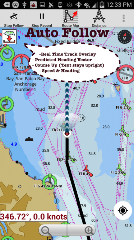
* Auto Follow Mode (Course up)
-Continuously updates boat's location on chart
- Adjustable update frequency
Sample Nautical Charts
Waikato River
Horomatangi Reef
Lake Taupo
Tapuaeharuru Bay
Evans Bay
Point Howard & Seaview Wharves
Lambton
Napier Roads
Napier
Westport
Westport
Horseshoe Bay-Ulva
Paterson Inlet/Whaka a Te Wera
Onehunga Wharf
Onehunga
Wellington
Kaikoura Peninsula-Banks Peninsula
Pukapuka
Penrhyn
Manihiki Anchorage
Penrhyn Taruia Passage-Gudgeon Bay
Nassau
Manihiki
Suwarrow
Opua Wharf
Kerikeri Inlet & Te Puna Inlet
Cape Reinga-Manukau
Cook Strait
Cape Adare-Cape Daniell
Nelson
Stewart/Rakiura-Macquarie
Port Taranaki
Nuku'alofa
Motiti-Pehitari Point
Ohiwa
Whakatane River
Chatham-Ile Rapa
Bluff
Cape Egmont-Rangitikei River
Foveaux Strait
Goat-Waiwera River
Tauranga
Waitangi Bay
Port Hutt
Stephens Passage
Te Aumiti (French Pass)
Port Gore
Forsyth & Guards Bays
Napier
Picton Wharves
Tory Channel Entrance
Picton
Dusky Sound
Great Barrier (Aotea)
Poor Knights, High Peak Rocks & Sugar Loaf Rock
Niuafo'ou
Frankton Arm-Queenstown Bay
Queenstown Bay
Lake Wakatipu
Queenstown Bay-Picnic Point
Calliope Wharves
Apia
Marlborough Sounds
Auckland
Port Golden Bay (Tarakohe)
Abel Tasman
Port Underwood
Ingles Bay
Norfolk-Cape Egmont
Marsden Point
Kawhia
Rauoterangi Channel & Kapiti
Cape Royds-Pram Point
Tamaki River
Port Pegasus/Pikihatiti
Port Adventure & Lords River/Tutaekawetoweto
Okurei Point
Neiafu
Deep Cove
LPG Terminal
Tasman Sea New Zealand-S.E. Australia
Alofi Landing
Alofi Anchorage
Niue
Chatham
Bream Tail-Kawau(incl. Aotea)
Macauley
Raoul
Curtis & Cheeseman
Tonga
Cape Karikari-Cape Brett
Otago
Riverton/Aparima
Balleny Seamount
Balleny
Cavalli Passage
Samoa
Lyttelton/Whakaraupo
Port of Lyttelton
Nuku'alofa
McMurdo Station & Scott Base
Cradock Channel & Mokohinau
Whanganui River Castlecliff Wharves
Samoa
Timaru
Coral & Solomon Seas & adjacent seas
Kaipara
Wairoa River
Mangonui
Whangaruru
Parengarenga
Breaksea Sound & Dusky Sound
Banks Peninsula-Otago Peninsula
Samoa-Tonga including Niue
Niuatoputapu
Porirua
Apolima Strait
Matautu Bay
Katiki Point-Nugget Point
Whangarei
Great Barrier
Smith-South Cape
North Cape
Doubtless Bay
Whangaroa
Anchorage Bay
Antipodes
Perseverance
Campbell/Motu Ihupuku
Bounty Islands
Castle Point-Cape Palliser
Milford Sound / Piopiotahi
Previous Versions
Here you can find the changelog of Marine Navigation -New Zealand since it was posted on our website on 2016-12-25 05:27:49.
The latest version is 100.0 and it was updated on 2024-04-19 21:06:13. See below the changes in each version.
Marine Navigation -New Zealand version 100.0
Updated At: 2016-11-10
Changes: -ENC/Vector maps support.
Disclaimer
Official Google Play Link
We do not host Marine Navigation -New Zealand on our servers. We did not scan it for viruses, adware, spyware or other type of malware. This app is hosted by Google and passed their terms and conditions to be listed there. We recommend caution when installing it.
The Google Play link for Marine Navigation -New Zealand is provided to you by apps112.com without any warranties, representations or guarantees of any kind, so access it at your own risk.
If you have questions regarding this particular app contact the publisher directly. For questions about the functionalities of apps112.com contact us.